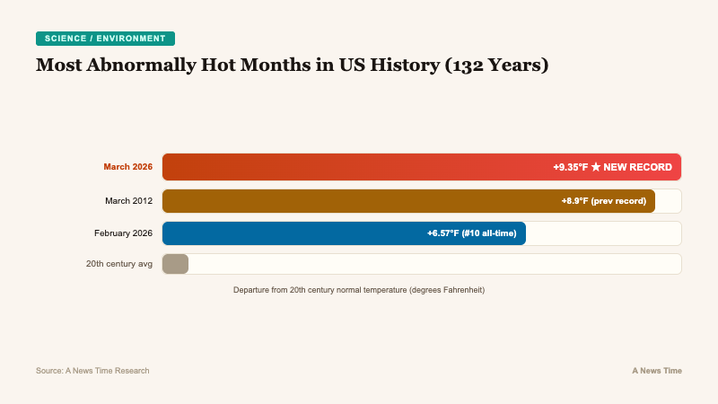
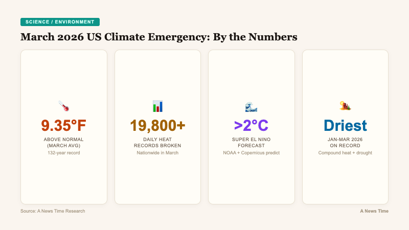
The continental United States registered its most abnormally hot month in 132 years of records in , according to data released by the National Oceanic and Atmospheric Administration on . The average temperature of 50.85 degrees Fahrenheit was 9.35°F above the 20th century normal for March, shattering the previous record of 8.9°F set in as the most abnormally hot month ever recorded for the Lower 48 states, regardless of the calendar month.
A Record That Dwarfs All Others in 132 Years
The scale of March's anomaly is difficult to overstate. The 9.35°F departure from normal did not merely break the previous record; it exceeded it by nearly half a degree Fahrenheit, a margin that in climatological terms represents a significant jump rather than an incremental shift.
The average maximum daytime temperature was even more extreme, reaching 11.4°F above the 20th century average, a figure that was almost a full degree warmer than the average daytime high for April. In effect, March 2026 was hotter during the day than a typical April, a displacement of seasonal norms that has cascading implications for agriculture, water management, and wildfire risk.
Six of the nation's top 10 most abnormally hot months have occurred in the last 10 years. , at 6.57°F above normal, ranked as the 10th highest departure ever recorded. The 12-month period from through was the warmest such period on record for the continental United States.
"What we experienced in March across the United States was unprecedented. One reason that's so concerning is just the sheer volume of records, all-time records that were set and broken during that time period. But also this is coming on the heels of what was the worst snow year. And the hottest winter of record."Shel Winkley, Meteorologist, Climate Central
19,800 Daily Records Shattered Across the Country
The aggregate statistics are staggering. More than 19,800 daily temperature records were broken for heat across the country in March, according to meteorologist Guy Walton's analysis of NOAA data. More than 2,000 locations set monthly heat records, a category that is significantly harder to break than daily records because it requires sustained warmth rather than a single spike.
To put the monthly record count in perspective: more March heat records were broken in the single month of than in entire decades of the past. The density of record-breaking events indicates that the heat was not localized to a single region but spread across the contiguous US in a pattern that Climate Central calculated would have been "virtually impossible without human-caused climate change."
On and , approximately one-third of the nation experienced temperatures that Climate Central's Climate Shift Index attributed directly to anthropogenic warming. The index measures whether observed temperatures would be expected in a world without human influence on the climate system.
| Rank | Month/Year | Departure from 20th Century Average |
|---|---|---|
| 1 | March 2026 | +9.35°F |
| 2 | March 2012 | +8.9°F |
| 3-10 | Various (6 of 10 in last decade) | Various |
| 10 | February 2026 | +6.57°F |
"All those broken records tells us that climate change is kicking our butts. January through March period was the driest on record for the contiguous U.S. So not only was it hot, it was record dry as well. And that's a bad combination for water availability, for agriculture, for river levels, for navigation."Jeff Masters, Meteorologist, Yale Climate Connections
Record Drought Compounds the Heat Emergency
The heat did not arrive in isolation. The through period was the driest on record for the contiguous United States, creating a compound emergency that affects far more than temperature readings.
Dry conditions and extreme heat interact in ways that amplify each other's damage:
- Wildfire risk: The Springs Fire in Southern California's Moreno Valley in early April was one of several blazes fueled by the combination of drought and heat
- Agricultural stress: Crops in the Southwest and Plains states faced simultaneous heat stress and water scarcity during a critical early growing season
- Water infrastructure: River levels for navigation and reservoir levels for municipal water supply both suffered from the dual pressure
- Snowpack deficit: The winter of 2025-2026 produced the worst snow year on record, leaving western water systems without the spring melt they depend on
A Super El Nino Is Forming, and It Could Be Historic
As if the current conditions were not concerning enough, federal and international forecasters are now predicting a "super" strong El Nino to form in the coming months and intensify through the winter. Both NOAA and the European climate service Copernicus are forecasting the event to reach well above 2 degrees Celsius above normal in the key Pacific monitoring region, a threshold that would place it in territory informally classified as "super-sized" and potentially rivaling the records set in and .
An El Nino is a natural, temporary, and cyclical warming of parts of the central Pacific Ocean that alters weather patterns across the planet. It is classified as moderate at 1°C above normal and strong at 1.5°C. The forecast of well above 2°C would place this event among the most powerful on record.
El Ninos release heat stored in the upper ocean into the atmosphere, which causes global temperatures to rise with a lag of several months. The implication is clear.
"A strong El Nino could plausibly push global temperatures to new record levels in late 2026 and into 2027."Victor Gensini, Professor of Meteorology, Northern Illinois University
The global climate imbalance that scientists have been tracking would be further amplified by a super El Nino, creating conditions for what could be the hottest year in human recorded history.
Super El Ninos Can Permanently Shift Climate Patterns
Research published in in the journal Nature Communications found that super-sized El Ninos often trigger what scientists call a "climate regime shift," pushing normal conditions into a different pattern that persists for years or decades rather than reverting to the previous baseline.
The study documented that after the - El Nino, the Gulf of Mexico jumped to a new sustained level of warmth that may have contributed to stronger hurricanes along the Gulf Coast in the subsequent years. If the predicted 2026-2027 El Nino reaches comparable intensity, a similar regime shift could affect other ocean basins and regional climate patterns.
Growing research also suggests that a warming world from the burning of coal, oil, and natural gas could be making El Ninos stronger, though climate scientists note this is not yet a consensus finding. The mechanism is intuitive: a warmer ocean has more stored heat available to release during El Nino events, potentially amplifying their intensity.
"Global warming is supercharging El Ninos and the atmospheric warming they drive. We saw this in 2016 and more recently in 2023. We're likely to see another jump in global temperatures if a strong El Nino develops later this year as being predicted."Jonathan Overpeck, Dean, School for Environment and Sustainability, University of Michigan
What El Nino Means for US Weather Patterns
A strong El Nino would alter weather patterns across the United States in predictable ways, though the specific impacts depend on the event's strength and timing:
- Atlantic hurricane suppression: El Ninos tend to increase wind shear over the Atlantic, reducing hurricane formation and intensity. This would be welcome news after several active hurricane seasons.
- Pacific storm amplification: The opposite pattern holds in the Pacific, where El Ninos increase tropical cyclone activity
- Southwest drought relief: El Ninos typically bring above-average precipitation to the American Southwest, which could partially alleviate the ongoing drought crisis
- Warmer northern US winters: The jet stream pattern during El Nino events typically brings milder temperatures to the northern tier states
- Wetter Southeast: The Gulf Coast and Southeast often experience above-average rainfall during strong El Nino winters
The potential for Southwest drought relief is a rare silver lining in an otherwise alarming forecast. The region's water infrastructure has been under severe stress, and the economic implications of energy and water scarcity extend far beyond the affected communities.
What We Still Do Not Know
For all the data pointing in one direction, significant uncertainties remain in the climate picture for the rest of 2026 and beyond:
- El Nino timing and peak: Forecasts predict formation in the coming months, but the exact timing and peak intensity remain uncertain. El Nino predictions made this far in advance carry meaningful error bars.
- Regime shift mechanics: The Nature Communications study identified the pattern but the physical mechanisms driving permanent climate shifts after super El Ninos are not fully understood.
- Interaction with Iran war emissions: The war's impact on global emissions (both from military operations and disrupted energy markets) adds an unmeasured variable to near-term climate projections.
- Whether El Ninos are truly strengthening: The link between global warming and El Nino intensity remains an active area of research without scientific consensus.
What is not uncertain is the trajectory. March 2026 broke a record that stood for 14 years by a significant margin. The hottest 12-month stretch in US history just concluded. A potentially historic El Nino is forming. Each of these developments individually would warrant attention. Together, they describe a climate system that is shifting faster than the infrastructure, policy, and disaster response systems built for the 20th century can accommodate. The data from March is not an aberration. It is a data point on a curve that continues to steepen.